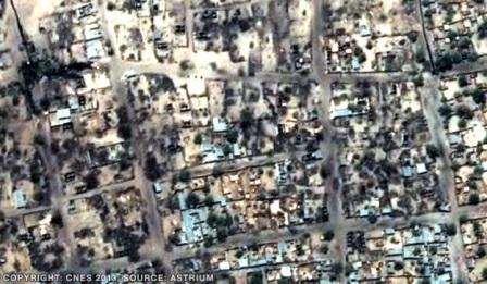
The Federal Government will on Monday give its own version of the Baga Massacre courtesy of
satellite images captured by the nation’s earth observation satellite, otherwise known as NigeriaSat-2.
It has been learnt that the Minister of Science and Technology, Prof. Ita Ewa Bassey, would show the images in a public ceremony in an attempt to counter the claim of a human right organisation.
The Human Rights Watch had on Wednesday denounced military’s claim that the fires that razed thousands of buildings in Baga, Borno State, were caused by rocket-propelled grenades fired by members of the violent Islamic sect, Boko Haram.
HRW, in a statement on its website, had said that satellite images showed that soldiers might have set the fires, claiming that a total of 2,275 buildings were razed while 125 others were severely damaged.
It was learnt that the planned public presentation of satellite images by Ewa is to counter the claim of the human right group.
President Goodluck Jonathan had recently directed the Defence Headquarters and the National Emergency Management Agency to investigate the incident. Both organisations submitted their preliminary reports to the President last week.
According to a statement by the Special Adviser to the President (Media and Publicity), Dr. Reuben Abati, DHQ’s findings showed that 30 terrorists were killed during the crisis. It also said that six bodies were recovered in Lake Chad about three kilometres away from the action spot.
In its report, NEMA stated that a number of buildings and business premises were destroyed in Baga. It claimed that the total number of houses in the community was far less than 1,000.
But the HRW, in the statement by its Africa Director, Daniel Bekele, said that the area damaged by fires measured about 80,000 sq2.
Stating that the fires were detected by the MODIS sensor aboard NASA satellites, Aqua and Terra, the HRW said its findings corroborated claims by the residents that 2,000 houses and 183 bodies were burnt during the mayhem.
The HRW had said, “Because of the number of buildings destroyed as well as their distribution across large sections of the town, we believe that such fires were intentionally set and not inadvertently sparked by the detonation of rocket-propelled grenades or improvised explosive devices.
“Such weapons could not ignite fires on such a wide scale, nor could they set fires to non-attached structures. Small arms and light weapons do not contain the amount of explosive or incendiary material to produce such a scale of damage.
“Baga residents told HRW that soldiers ransacked their town after the Boko Haram militant Islamist group attacked a military patrol, killing a soldier. Community leaders said that immediately after the attack they counted 2,000 burned homes and 183 bodies. Satellite images of the town analysed by HRW corroborate these accounts and identify 2,275 destroyed buildings, the vast majority likely residences, with another 125 severely damaged.”
Many commentators had descended on HRW since it made the claim that 2,275 houses were burnt in Baga.
While some accused the organisation of bias, others said its figures had been exaggerated.
In a telephone interview with our correspondent, spokesman for the National Space Research Development Agency, Mr. Felix Ale, confirmed that the agency was in possession of satellite images of the incident and would soon make them public.
Nigeria has been able to put three earth observation satellites and two communication satellites in space since 2003 when the first satellite, known as Nigeria Sat-1 with a resolution of 32 metres, was constructed. It was recently deorbited having reached the end of its lifespan.
Nigeria Sat-2 satellite was then launched in 2010 and is equipped with three payloads to get three different resolutions – 2.5Metres, five metres and 32Metres.
NigeriaSat-X was constructed by Nigerian engineers with the assistance of engineers from the contractors of the two other earth observation satellites, Surrey Satellite Technology Limited.
Meanwhile, the Presidency has insisted that contrary to media reports, the recent incident in Baga, was not a case of massacre.
This was made known by Abati, in an interview with SaharaTV on Saturday.
He said, “The position of the government is that there was no massacre in Baga. Two, the reports by investigators also made it clear that the Boko Haram terrorists were the ones who set houses on fire, and the ones who have turned Baga into an enclave within the Nigerian State. And to the extent that that is true means that the terrorists are determined to violate the sovereignty of Nigeria,” Abati said.
He insisted that the figures given by the media and human rights activists could not be substantiated.
The president’s spokesman, who confirmed that he had seen the satellite images of the incident being circulated by HRW, described them as questionable.
He said, “I have seen the satellite images that are being circulated. But you know those satellite images are questionable. You know that satellite imagery is determined by a lot of variables: weather condition, the quality of equipment, the resolution, the distance, the all of that.
“And the military authorities have made it very clear that the Nigerian authorities have also carried out their own satellite imagery using Nigeria’s tools. And the evidence that they have is clearly different from the evidence that the Human Rights Watch is talking about.”

